
Build a complete hydrologic model of your area to understand flood risks and assess inundation in real time
Flood readiness, management, and recovery are huge responsibilities that often get divided across multiple teams. We can help anybody improve their approach to water, including:
Build a complete hydrologic model of your area to understand flood risks and assess inundation in real time
Understand water volume, flow, and stress on your infrastructure to make critical water control decisions

Get the reliable data you need to improve the timeliness and impact of severe storm and flood response

Identify exactly where infrastructure improvements and maintenance are needed to build a safer community

Know when and how heavy storms might impact your work to maximize continuity and keep people safe
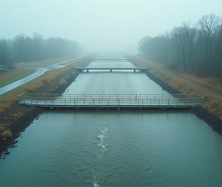
As an end-to-end partner, we provide integrated technology and services to help you monitor, prepare for, and respond to all forms of flooding—whether it’s caused by intense rainfall, snowmelt, storm surges, or infrastructure failure.
Accelerate your public safety response with automated road closures and alerts during floods.
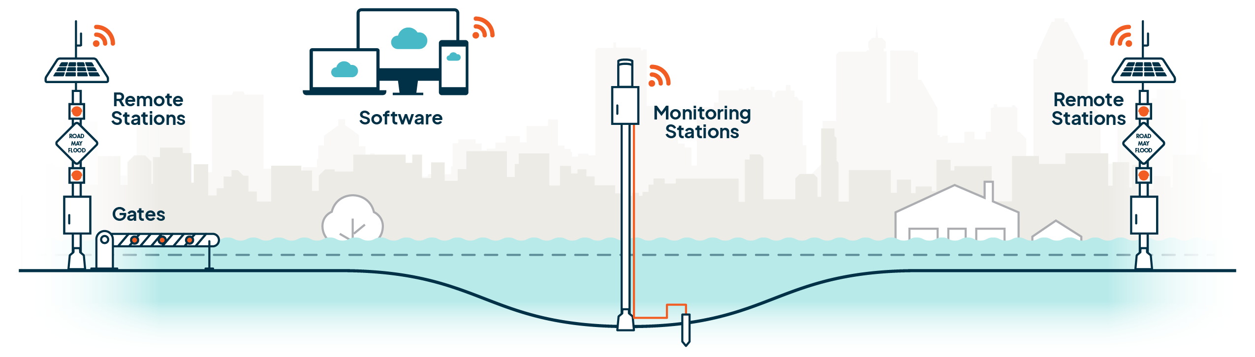
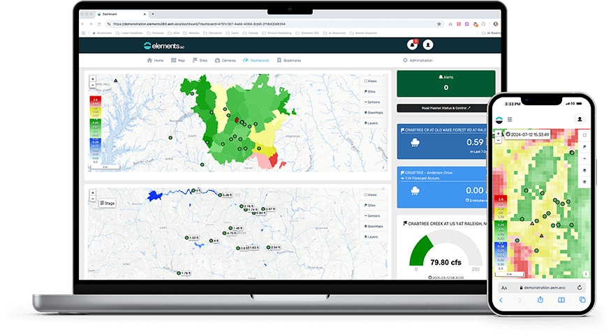
Bring data from the field, high-accuracy forecasts, radar, and weather alerts together to create a flood command center.
Measure water levels, flow rates, and precipitation in your area to identify inundation as quickly as possible.
Create a connected network of flood stations that deliver coordinated alerts, helping reduce risk across your entire road network.


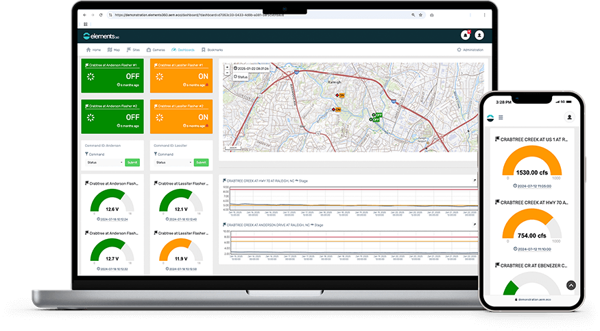 Comprehensive flood dashboard with real-time and forecast data
Automated alerting engine with role-based notifications
Secure and scalable to support interagency collaboration
Comprehensive flood dashboard with real-time and forecast data
Automated alerting engine with role-based notifications
Secure and scalable to support interagency collaboration
 Integrates surface and subsurface runoff for a more precise prediction.
Continuously refines predictions using real-time sensor data, Gauge-Adjusted Radar Rainfall (GARR), and AI-driven analysis.
Delivers reliable predictive data up to three days in advance, improving preparedness efforts.
Integrates surface and subsurface runoff for a more precise prediction.
Continuously refines predictions using real-time sensor data, Gauge-Adjusted Radar Rainfall (GARR), and AI-driven analysis.
Delivers reliable predictive data up to three days in advance, improving preparedness efforts.
 More accurately characterizes rainfall by providing a rainfall measurement between rain gauges.
Unique quality controlled, spatially- and temporally-varied approach.
Receive hyperlocal rainfall data when rain gauges fail or during radar outages.
More accurately characterizes rainfall by providing a rainfall measurement between rain gauges.
Unique quality controlled, spatially- and temporally-varied approach.
Receive hyperlocal rainfall data when rain gauges fail or during radar outages.
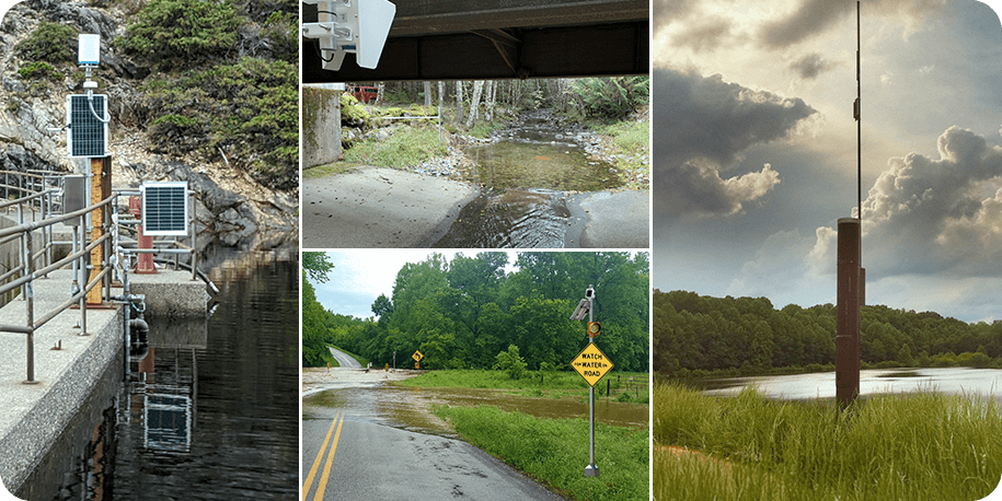 Reliable data monitoring to support your flood early warning system
Flexible options for network creation, expansion, and infill on any budget
Automated warning lights and gates for flood awareness and public safety
Reliable data monitoring to support your flood early warning system
Flexible options for network creation, expansion, and infill on any budget
Automated warning lights and gates for flood awareness and public safety
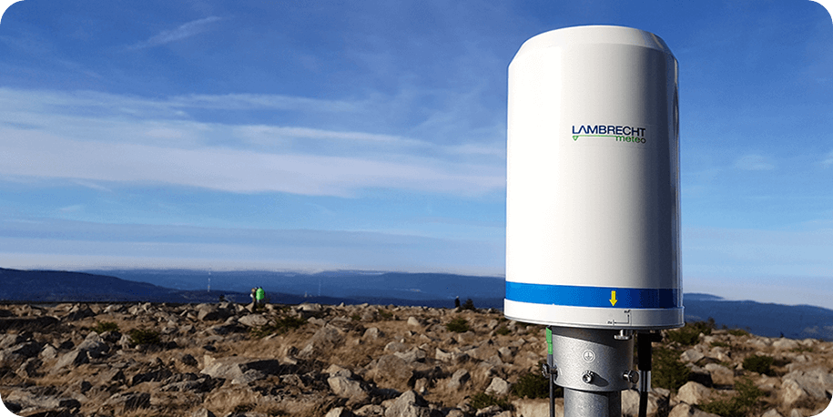 Scientific precision for tracking rain, snow, and every form of precipitation
Self-emptying, self-heated design to reduce maintenance trips to the field
Built-in data validation with both a weighing sensor and tipping bucket
Scientific precision for tracking rain, snow, and every form of precipitation
Self-emptying, self-heated design to reduce maintenance trips to the field
Built-in data validation with both a weighing sensor and tipping bucket
Wherever you are in your flood readiness journey – starting from scratch, making targeted improvements, or just trying to figure out how you can get better – we can help you find the next step forward.
Schedule a flood consultationNot ready to speak to a member of our team? Take a 5-minute self assessment here

“We felt that…[AEM’s Vflo]…model…worked better than other proposals for urban areas and the flashy flood situations that we have. I think we made a wise choice because the watch points that we have in our system, it’s amazing how accurate they are…on the timing and the height.”
Kelly Daniel, Flood Early Warning System Engineer & Project
“We’ve always had a great support structure through Contrail [AEM Elements 360]…and now through Contrail Camera. Having the experts available to integrate a new camera or help us with any troubleshooting or if something comes up, as opposed to relying on internal IT to troubleshoot something…That takes a lot of stress out.”
Alex Doran, Engineering Tech Specialist (Hydrology)

“When Contrail [now called AEM Elements 360] came on board, it was our one-stop toolbox…All the alarming, dashboards, everything that we had in multiple locations before, were now consumed into one toolbox…Simple maps to go in and look at details of gauges and sensor types. Turning on and off layers…It finally all came together when we installed Contrail.”
Joshua McSwain, Senior Business Analyst

“With [AEM], it’s really easy to see how much rain is happening and see how high the river’s getting all in one spot… Prior to this, I would be looking at three-to-four different websites: one showing rainfall, one showing me stream height… This pulls it all together.”
Craig Ottman, Water Resources Engineer

“What AEM offers is the complete package for an organization wanting a flood warning system, or to upgrade what they already have. The system is really scalable. Whether it's software or hardware or complete system design and maintenance support, you can do everything under one roof with one partner.”
Matt Friedberg, Flood Warning System Operator


Flood risk management is incredibly challenging because “a flood” isn’t just one predictable hazard that plays by the same rules in every scenario. Click the circles on the map below to learn more about how flooding presents unique challenges in different settings and contexts.
Flash floods develop incredibly quickly in dry, arid, or drought-ridden areas because the soil cannot absorb rainfall properly.
In areas where wildfires, logging, or development have reduced trees, floodwaters can rapidly reshape the land in undesired ways.
Major infrastructure is susceptible to overtopping and potential failure when owners and operators don’t manage with extreme rainfall events in mind.
Rainfall or snowmelt can overwhelm small waterways, leading to backup and flooding in urban, suburban, and rural communities.
Heavy rainfall can overwhelm urban stormwater and wastewater infrastructure, leading to streets and homes flooding.
Floods can endanger livestock, wash soil away, and spoil crops by promoting mold growth, impacting the food supply.
Over half of all flood-related drownings occur when a vehicle is driven into hazardous flood water.
Tidal storm surge, river flooding, and multi-day storms can all cause levees to fail from strain or become overwhelmed by rising waters.
Tidal storm surges and tsunamis can cause rapid flooding in communities where the land meets the sea.
In general, yes. meteorologists can predict heavy rainfall days in advance, and with an accurate hydrologic model of their area, local leaders can turn that data into an accurate prediction of how the forecasted storm will translate to flood inundation in their area. With that said, the quality of the forecast and the model both need to be high to create the best possible prediction.
A flood warning system is an early flood monitoring solution that deploys accurate and well-maintained sensing instruments, like rain gauges, water level sensors, and flow rate sensors. The data from these sensors then utilizes a reliable and robust communications systems and a central base station to allow the data to be processed, analyzed, and monitored. When a threshold is reached across any of the sensors, an automated alert is sent out to initiate emergency action plans.
Locally owned and operated automated flood early warning systems help save lives and reduce property damage by providing critical, real-time information to the National Weather Service and public officials at all levels of state and local government to issue alerts warning people who are vulnerable to flooding.
To begin your flood planning, a flood risk analysis should be completed, evaluating the risk of flooding and the vulnerability of the specific area. Things that need to be taken into consideration are topography, infrastructure, climate, frequency of storms over an area, and more. Read our Flood Resilience and Planning Solutions Guide to learn more.
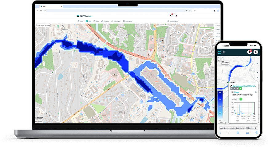
Hydrological forecasting provides flood inundation mapping enabling advanced lead time to flooding conditions and indicates which areas might be impacted with flooding conditions.
Levees, designed to protect communities against flooding, can be particularly vulnerable during intense storm events. Heavy rainfall can put levees at risk of overtopping and the consequences can be catastrophic. Additionally, deterioration and failure due to erosion is of particular concern for communities living near or behind a levee. During high water events, erosion can take place at or below the water surface. Even if a levee is being patrolled during an event, unseen erosion can be threatening the levee’s structural integrity.
Wildfires cause serious damage to property and communities. With vegetation gone, rainfall can cause debris flows and flash floods. With fires that burn hot, the soil can become hydrophobic, increasing runoff and the potential for dangerous flooding, debris flows and landslides. With remote difficult terrains and lack of communications infrastructure, monitoring for potential flood threatening conditions can be challenging.
Have questions about anything you’ve read? Ready to see how AEM’s flood services could improve severe weather resilience in your community? Fill out the form below to get a conversation started.