Hydromet Services
Take decisive action to protect communities and infrastructure. Our tools and services help you accurately track rainfall and model incoming storms.
Take decisive action to protect communities and infrastructure. Our tools and services help you accurately track rainfall and model incoming storms.

We monitor national and global networks. No job is too complex.

From control room to field unit, access reports on any device.

Our trained meteorologists answer your questions, any time.
Expert analytics
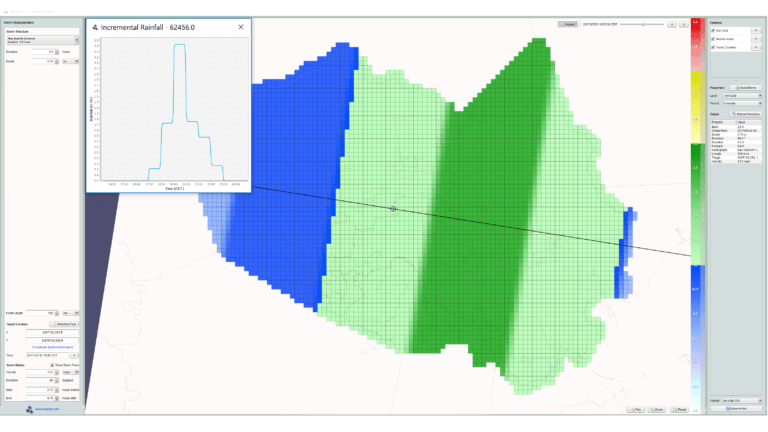
Our Storm Builder tool lets you model dynamic storm characteristics and analyze the impacts with hyetographs analysis, storm motion, and spatially variable depth. Access valid, reproducible hydraulic modeling results every time.

flood prediction
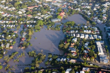
Gauge-adjusted Radar Rainfall (GARR) tracks rainfall between installed gauges. When you know precisely where rain is falling, you unlock accurate flood warnings – as well as rigorous data for hydrological planning and regulatory reports.
GARR is useful for characterizing rainfall within the context of sanitary sewer collection system planning, design, rehabilitation and operations. GARR is distinguished by its accuracy and representativeness at high resolution, both spatially and temporally over broad areas. This spatially variable radar rainfall data is needed for characterizing sewer system responses to wet weather.
GARR is a more accurate and representative rainfall distribution, and it is less sensitive to individual rain gauge malfunction than distributed gauge-only rainfall measurements.

data and insights
Access decades of rainfall data, interactive maps, and modeling – unlocking the insights that help you make better decisions. We help you compile all this information in one system, on desktop or mobile.

INNOVATIVE HYDROMET SOLUTIONS
We design and manufacture extremely rugged systems, data loggers, DCPs, and sensors for hydrology and hydromet monitoring. Our focus is to make our customers successful in their efforts to monitor, record and analyze changes in the natural environment.
We don’t just manufacture equipment; we constantly innovate advanced environmental monitoring technology. Because we understand our customers and their goals, our technology is engineered specifically for harsh environments in remote locations. It also has to operate continually, reliably, for long periods of time, with minimal maintenance requirements and ease-of-use.
We’ve developed the world’s first turbidity event-triggered sampling system that can determine sediment and nutrient loads more accurately than with traditional methods. It provides the best method of characterizing impairments, ensuring sound decisions affecting public safety are made, and best management practices are implemented and effective.

AEM Elements 360 is a multi-hazard weather intelligence solution and the cornerstone of the Elements Resiliency Platform.

Data visualization platform for spatially distributed rainfall and flood prediction information.
Our unique approach of combining rain gauge and radar data delivers a more accurate rainfall measurement.
Apply dynamic design storm characteristics to achieve valid, reproducible hydraulic modeling results.