Wildfire Fuels Data
AEM’s Wildfire Fuels Data delivers the world’s most advanced, dynamic fuel layers—every 10 days, anywhere on the planet. Built for accuracy and global scale, it’s the new gold standard for predictive wildfire modeling.
AEM’s Wildfire Fuels Data delivers the world’s most advanced, dynamic fuel layers—every 10 days, anywhere on the planet. Built for accuracy and global scale, it’s the new gold standard for predictive wildfire modeling.

Updated every 10 days so your models reflect real-world risk—not outdated assumptions.
Get scalable data worldwide or hyperlocal, with domain-specific fuel types.

Structural and drought classifications offer greater modeling accuracy.

GLOBAL REACH
AEM provides the only globally consistent, high-resolution wildfire fuels dataset. Global Generic Fuels deliver reliable data anywhere, while Domain Specific Fuels add more nuanced classifications based on local vegetation maps. This means better insights whether you’re planning mitigation across continents or modeling fire spread in a specific state forest.

accurate inputs
You can’t predict today’s fire with last year’s data. Unlike other data sets that include outdated inputs, AEM delivers current, high-resolution data that reflects real-world conditions. Refreshed every 10 days at 20-meter resolution, our wildfire fuels data captures detailed changes in vegetation, drought stress, and fuel structure. The result? Smarter, more accurate fire behavior modeling when it matters most.

Rich data sets
We don’t just classify wildfire fuels—we understand them. Our Domain Specific Fuels Data are broken down by structural characteristics like canopy, height, and cover, as well as by drought state—normal, severe, and extreme. This granular approach, unique to AEM, delivers richer, more actionable inputs for fire modeling that reflect real-world conditions and evolving risk.
AEM’s data is used by a wide range of organizations that need accurate, up-to-date insights to assess and manage wildfire risk. Whether it’s for real-time operations, infrastructure protection, or long-range forecasting, our data supports smarter decisions at every level.
Government agencies and emergency services use wildfire fuels data to improve fire prediction, planning, and response. Utilities rely on it to evaluate wildfire exposure around power lines and critical infrastructure. Climate researchers and environmental organizations integrate it into models to understand long-term wildfire trends. AI and analytics companies also use it to power predictive fire models and decision-support tools.
Our Global Generic Wildfire Fuels Data is a simplified, scalable dataset designed to deliver consistent risk insights anywhere on Earth. With 20-meter resolution and updates every 10 days, it uses broad fuel categories—like evergreen forest, shrubland, and grassland—based on global satellite sources. It’s ideal for customers who need reliable, global coverage but don’t have access to detailed regional vegetation maps. Common users include developing country fire agencies, AI firms training fire risk models, and global risk assessment organizations.
The Domain Specific Wildfire Fuels Data is a more detailed, regionally optimized dataset that uses localized vegetation data to deliver higher fuel type accuracy. Built on the same 20-meter resolution and 10-day update cycle, it incorporates specific vegetation classifications and structural detail—enabling more precise fire modeling for regions like the U.S., Canada, and Australia. It’s best suited for advanced users such as government fire agencies, utilities, and fire modeling firms that require high-fidelity fuel data tailored to their region.
Data is typically delivered as GeoTIFF files for spatial layers and XML files for parameter definitions. These formats are compatible with most GIS platforms and fire behavior modeling systems, making it easy to integrate the data into your existing workflows.
Our wildfire fuels data goes beyond basic vegetation types by incorporating detailed structural characteristics—like canopy height, cover density, and stand structure—into each fuel classification. This level of detail allows for more accurate fire behavior modeling, particularly in how wind interacts with different vegetation structures. It also helps distinguish between surface and crown fire potential, and supports better predictions of how fires will move across varied landscapes, including transitions between natural and built environments

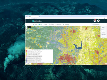
AEM Elements 360 is a multi-hazard weather intelligence solution and the cornerstone of the Elements Resiliency Platform.

Confirm wildfire ignition, access imagery with weather overlay data, and see real-time threats to lives and property.

Get exceptionally accurate wildfire weather data. Our Remote Automated Weather Stations are trusted in some of the world’s harshest locations.
