FTS360
Track weather changes, monitor conditions, and keep a close watch over high-risk locations in real-time before, during, and after an event with our intelligent wildfire software platform.
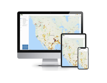
Track weather changes, monitor conditions, and keep a close watch over high-risk locations in real-time before, during, and after an event with our intelligent wildfire software platform.

View and curate sensor and station data, camera images, and video in one wildfire software platform.

Configure advanced calculations and intelligent alerts in our intuitive programming environment.

Edge to cloud data security protects your data and privacy.

intelligent camera technology
Intelligent camera guard tour technology in FTS360 wildfire software so you can easily pinpoint and watch high-risk locations in real time.

Public awareness

custom programming
NodeRED is a visual tool within FTS360 wildfire software that allows users to write, test and deploy custom programs in real-time.

Security and privacy
Edge to cloud data security protects your data and privacy:

Real-time data transmission
FTS invests in high-rate information transmission (HRIT) to ensure GOES data is received within seconds of being transmitted:

Advanced features
Customize to your wildfire software needs with optional upgrades including:

Get exceptionally accurate wildfire weather data. Our Remote Automated Weather Stations are trusted in some of the world’s harshest locations.

The ideal compact and rugged solution for managing hydrology and meteorology environmental parameters.

Confirm wildfire ignition, access imagery with weather overlay data, and see real-time threats to lives and property.

Our compact weather station can be customized to deliver quality, localized, real-time information to support prompt, intelligent decision making.

With sensors in 100+ countries, we provide the world’s most precise lightning network – measuring within 100m of your location.

Webinar
We discuss how wildfires are a major challenge for utilities and local agencies managing Wildland Urban Interface (WUI). This free, one-hour learning session focuses on how organizations are addressing the wildfire event curve head-on with leading monitoring tools and software, including how to:


